Summary information
| Repository: | South Peace Regional Archives |
| Title: | Ray Menard Alaska Highway collection |
| Reference code: | 0291 |
| Date: | 1942-1943 (date of creation) |
| Physical description: | 7 pp. textual records
92 photographs |
| Dates of creation, revision and deletion: | Processed by Karen Burgess, 2008 Added to new database August 2024 – TD |
| Note [generalNote]: | This fonds has been identified as having Indigenous related content. Researchers may encounter language that is outdated and offensive. To learn more about Indigenous records at the South Peace Regional Archives please see our guide. |
Administrative history / Biographical sketch
Ray Menard was born on Dec 17, 1914, in Gleichen, AB, and spent his childhood there. After he married Wilda, he worked for International Harvester in Calgary and then got work in a munitions plant in Ogden. In December, 1942, Ray moved to Dawson Creek. His wife, Wilda, moved up in the spring and they lived for a time with Jack Schmidt and his wife in a small trailer. Their children, Karen and Jody, stayed in Gleichen with their grandmother. Ray worked for Greyhound while he also built a small house for his family. The night of the Dawson Creek explosion, Ray and a friend were sitting in a restaurant in Dawson Creek when they noticed the fire. They still ordered dessert and then they heard a terrific explosion. He saw paper towels unravelling in the sky. The front glass window of the restaurant was shattered and the owner received cuts to his head and face. When they went back to their bunkhouse and saw that a tire from Rodacker’s Tire Shop had been thrown through the roof and cut one of the bunks in half. The explosion levelled an entire block of the town and every window for four blocks around was blown out. The U.S. army came down and took over to put the fire out.
Ray worked in Dawson Creek and along the Alaska Highway during 1942-44 servicing the International Busses that transported army personnel. The company he worked for was called AMA Trucking. It consisted of a small office, an old livery barn and an old farm barn on the property. Part of his job was building an addition to the livery barn. It was a former blacksmith shop adjacent to the block containing his place of work that blew up. The army had stored 500 pounds of dynamite there.
In the fall of 1944 he moved to Grande Prairie to work for Mel Rodacker in his machine shop. He put his lathe in the Mel’s bare new building and started work. His first job was for a contractor working at the airport construction job. When the machine shop became Steel Industries, Ray was part owner. Later he sold his shares in the company and worked for Worker’s Compensation Board.
In 2008, he resided in a senior’s care center in Hanna, AB.
Custodial history
These photographs were taken by Dan Murray, a good friend of Ray Menard, and Ray gave them to Alice Fortier who donated them to the South Peace Regional Archives in 2006.
Scope and content
The fonds consists of 92 photographs taken during the time Ray Menard worked as a mechanic and machinist on the construcion of the Alaska Highway between 1942-1943, including base camps, equipment and storage, winter road construction, summer construction, wrecks and spills, bridge work, and the Dawson Creek explosion. Included is a typed notation of photographs which have been identified and a newspaper article describing the Dawson Creek explosion and notes from an interview conducted by Linda White, his daughter.
Notes
Title notes
- Source of title proper: Title of fonds based on contents.
Access points
- Textual record (documentary form)
- Graphic material – photograph (documentary form)
- Military (subject)
- Transportation (subject)
Table of contents
0291.01, Base Camps, 1942-1943
0291.02, Equipment and Storage, 1942-1943
0291.03, Winter Road Construction – General, 1942-1943
0291.04, Winter Road Construction – Identified, 1942-1943
0291.05, Summer Road Construction – Identified, 1942-1943
0291.06, Wrecks and Spills, 1942-1943
0291.07, Rivers and Bridges, 1942-1943
0291.08, The Dawson Creek Explosion, 1943
Series descriptions
| Series 0291.01: Base Camps
Date: 1942-1943 (date of creation) Scope and content: The series consists of photographs of the Northwest Service Command U.S.A. busses and men, two men dressed in winter uniform, the muddy streets of Dawson Creek, a lumber mill and the Whitehorse Inn. Physical description: 7 photographs Access points: • Graphic material – photograph (documentary form) Publication status: Published |
|||
| File / item list | |||
| Reference code | Title | Dates | Physical description |
| 0291.01.01 | Item – Northwest Service Command U.S.A. Bus | 1942 | 1 photograph : b&w ; 3 x 5 in. |
| Scope and content:
A group of men lined up beside the bus, “Northwest Service Command U.S.A.” |
|||
| 0291.01.02 | Item – Fleet of Northwest Service Command U.S.A. Buses | 1942 | 1 photograph : b&w ; 3 x 5 in. |
| Scope and content:
Ray’s note on the back: “This is part of the fleet I’m in charge of. 14 in all. K7 Internationals with 29 passenger bodies in them. The one all torn apart is a new bus that we scrapped for parts.” |
|||
| 0291.01.03 | Item – Main Street Mud | 1942 | 1 photograph : b&w ; 3 x 5 in. |
| Scope and content:
A jeep with a “Taxi “ sign on the windshield has its driver’s side totally mired in the mud on Dawson Creek’s main street. A crowd on the sidewalk looks on. |
|||
| 0291.01.04 | Item – A Planer Mill | 1942 | 1 photograph : b&w ; 3 x 5 in. |
| Scope and content:
A planer mill in operation showing a pile of lumber, the planer shed and men working. A farm can be seen in the distance. |
|||
| 0291.01.05 | Item – Dawson Creek in Wet Weather | 1942 | 1 photograph : b&w ; 3 x 5 in. |
| Scope and content:
A view of a street in Dawson Creek, flooded after a rain. |
|||
| 0291.01.06 | Item – Whitehorse Inn | 1942 | 1 photograph : b&w ; 3 x 5 in. |
| Scope and content:
The Whitehorse Inn on a corner of main street. |
|||
| 0291.01.07 | Item – Two Men Outfitted for Winter | 1943 | 1 photograph : b&w ; 3 x 5 in. |
| Scope and content:
Two men dressed in winter clothing. |
|||
| Series 0291.02: Equipment and Storage
Date: 1942-1943 (date of creation) Scope and content: The series consists of photographs of rows of storage buildings, and equipment, heavy duty trucks, fire trucks, and fuel trucks. Physical description: 11 photographs Access points: • Graphic material – photograph (documentary form) Publication status: Published |
|||
| File / item list | |||
| Reference code | Title | Dates | Physical description |
| 0291.02.01-11 | Item – Equipment and Storage | 1942-1943 | 11 photographs : b&w ; 3 x 5 in. |
| Scope and content:
The series consists of photographs of rows of storage buildings, and equipment, heavy duty trucks, fire trucks, and fuel trucks in Dawson Creek for the Alaska Highway construction. |
|||
| Series 0291.03: Winter Road Construction – General
Date: 1942-1943 (date of creation) Scope and content: The series consists of photographs of various scenes along the constructed route of the Alaska Highway. “Frederiksen’s Lookout” and “Suicide Hill” are two of the signs shown and Muncho Lake is shown in one photo. Physical description: 13 photographs Access points: • Graphic material – photograph (documentary form) Publication status: Published |
|||
| File / item list | |||
| Reference code | Title | Dates | Physical description |
| 0291.03.01-13 | Item – Winter Road Construction | 1942-1943 | 13 photographs : b&w ; 3 x 5 in. |
| Scope and content:
Photographs of the road as constructed in the winter of 1942-43. |
|||
| Series 0291.04: Winter Road Construction – Identified
Date: 1942-1943 (date of creation) Scope and content: The series consists of photographs of various winter scenes of the construction of the Alaska Highway. Physical description: 20 photographs Access points: • Graphic material – photograph (documentary form) Publication status: Published |
|||
| File / item list | |||
| Reference code | Title | Dates | Physical description |
| 0291.04.01 | Item – Along Trout River | 1942 | 1 photograph : b&w ; 3 x 5 in. |
| Scope and content:
Image shows a lake in the mountains in the winter. |
|||
| 0291.04.02 | Item – Dog Team at Mile 8 N. | 1942 | 1 photograph : b&w ; 3 x 5 in. |
| Scope and content:
Image shows a team of three dogs pulling a sled. A boy is sitting on the loaded sled, and a man is standing beside it. |
|||
| 0291.04.03 | Item – Along the Toad River 148 N. | 1942 | 1 photograph : b&w ; 3 x 5 in. |
| Scope and content:
A man believed to be Ray Menard stands beside the Toad River. |
|||
| 0291.04.04 | Item – Highway at 148 J. | 1942 | 1 photograph : b&w ; 3 x 5 in. |
| Scope and content:
A view of the highway over the hills at148 J. |
|||
| 0291.04.05 | Item – Summit Lake Army Camp | 1942 | 1 photograph : b&w ; 3 x 5 in. |
| Scope and content:
Army trucks with the mountains in the distance at Summit Lake Army Camp. |
|||
| 0291.04.06 | Item – Mackey’s Camp 177 | 1942 | 1 photograph : b&w ; 3 x 5 in. |
| Scope and content:
A line of army trucks with mountains in the background at Mackey’s Camp 177. |
|||
| 0291.04.07 | Item – Along the Testa River | 1942 | 1 photograph : b&w ; 3 x 5 in. |
| Scope and content:
Trucks in the distance along the Testa River. |
|||
| 0291.04.08 | Item – Along the Toad River N. | 1942 | 1 photograph : b&w ; 3 x 5 in. |
| Scope and content:
Image shows a gravel road through the mountains. There is a vehicle in the distance. |
|||
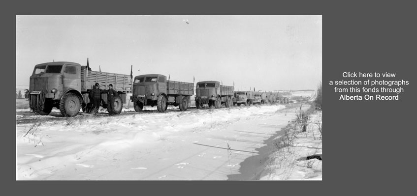
| 0291.04.09 | Item – Dynamite Convoy Leaving Dawson Creek | 1942 | 1 photograph : b&w ; 3 x 5 in. |
| Scope and content:
Image shows a convoy of trucks on a road in the winter. There are two men standing in front of the first truck. |
|||
| 0291.04.10 | Item – Muncho Lake in a Snowstorm | 1942 | 1 photograph : b&w ; 3 x 5 in. |
| Scope and content:
Image shows frozen Muncho Lake during a snowstorm. There are trees in the foreground and a mountain in the background. |
|||
| 0291.04.11 | Item – [Indigenous Man with Dogs] Original Title: Native Man With Pack Dogs | 1942 | 1 photograph : b&w ; 3 x 5 in. |
| Scope and content:
Image shows an Indigenous man standing outside in the snow with two dogs. The caption on the back of the photograph says “Eskimo + his dogs.” |
|||
| 0291.04.12 | Item – 147 N. Toad River | 1942 | 1 photograph : b&w ; 3 x 5 in. |
| Scope and content:
Image shows a road through the mountains in the winter. |
|||
| 0291.04.13 | Item – Convoy Resting in Sikanni Valley | 1942 | 1 photograph : b&w ; 3 x 5 in. |
| Scope and content:
Image shows a convoy of loaded trucks parked on the road. There is a building to the right. |
|||
| 0291.04.14 | Item – Anderson’s Camp 107 N. | 1942 | 1 photograph : b&w ; 3 x 5 in. |
| Scope and content:
Anderson’s Camp 107 N with mountains in the background. |
|||
| 0291.04.15 | Item – Summit Lake Army Camp | 1942 | 1 photograph : b&w ; 3 x 5 in. |
| Scope and content:
Image shows the buildings of Summit Lake Army Camp with mountains in the background. Some of the buildings appear to be under construction. |
|||
| 0291.04.16 | Item – Caswell’s 87.5 N. | 1942 | 1 photograph : b&w ; 3 x 5 in. |
| Scope and content:
Caswell’s camp 87.5 N in winter. |
|||
| 0291.04.17 | Item – Anderson’s Camp 107 N. | 1942 | 1 photograph : b&w ; 3 x 5 in. |
| Scope and content:
Image shows a building under construction in Anderson’s Camp, with mountains in the background. |
|||
| 0291.04.18 | Item – Suicide Hill | 1942 | 1 photograph : b&w ; 3 x 5 in. |
| Scope and content:
A man watches as a tanker truck proceeds towards Suicide Hill. Another truck can be seen approaching. |
|||
| 0291.04.19 | Item – Frederiksen’s Lookout | 1942 | 1 photograph : b&w ; 3 x 5 in. |
| Scope and content:
A man stands beside a sign describing “Frederiksen’s Lookout.” |
|||
| 0291.04.20 | Item – Muncho Lake | 1942 | 1 photograph : b&w ; 3 x 5 in. |
| Scope and content:
Muncho Lake seen on the left of the newly built Alaska Highway. |
|||
| Series 0291.05: Summer Road Construction – Identified
Date: 1942-1943 (date of creation) Scope and content: The series consists of photographs of summer road construction of the Alaska Highway. Physical description: 4 photographs Access points: • Graphic material – photograph (documentary form) Publication status: Published |
|||
| File / item list | |||
| Reference code | Title | Dates | Physical description |
| 0291.05.01 | Item – Seismograph Camp | 1942 | 1 photograph : b&w ; 3 x 5 in. |
| Scope and content:
Seismograph Camp: Note on the back of photo, “Photo was taken by moonlight 32’ F.” |
|||
| 0291.05.02 | Item – [Indigenous Pack Train] | 1942 | 1 photograph : b&w ; 3 x 5 in. |
| Scope and content:
As a pack train gets organized, two Indigenous horsemen are mounted and ready to head out. |
|||
| 0291.05.03 | Item – Dynamite Convoy | 1942 | 1 photograph : b&w ; 3 x 5 in. |
| Scope and content:
A convoy of trucks carry dynamite caps. |
|||
| 0291.05.04 | Item – Convoy on the Alcan | 1943 | 1 photograph : b&w ; 3 x 5 in. |
| Scope and content:
A convoy of heavy equipment including flat-bed trucks loaded with caterpillar tractors is held up while road repairs are made ahead. |
|||
| Series 0291.06: Wrecks and Spills
Date: 1942-1943 (date of creation) Scope and content: The series consists of photographs of various scenes of some of the dangers encountered during the construction of the Alaska Highway. Physical description: 9 photographs Access points: • Graphic material – photograph (documentary form) Publication status: Published |
|||
| File / item list | |||
| Reference code | Title | Dates | Physical description |
| 0291.06.01 | Item – Bus Hits the Ditch | 1943 | 1 photograph : b&w ; 3 x 5 in. |
| Scope and content:
A Greyhound Bus goes off the road near Valleyview enroute to Dawson Creek. |
|||
| 0291.06.02 | Item – Trucks Pile up on Corner | 1943 | 1 photograph : b&w ; 3 x 5 in. |
| Scope and content:
Two trucks are piled up off a corner as two others try to make the grade. |
|||
| 0291.06.03 | Item – F.W.D. in Distress | 1943 | 1 photograph : b&w ; 3 x 5 in. |
| Scope and content:
A supply vehicle failed to make the corner and lies on its side in the ditch with the load spilled into the snow. |
|||
| 0291.06.04 | Item – Dumped Load | 1943 | 1 photograph : b&w ; 3 x 5 in. |
| Scope and content:
A completely overturned vehicle lies in the ditch with its dumped load of crates. |
|||
| 0291.06.05 | Item – Fuel Truck Slides off the Road | 1943 | 1 photograph : b&w ; 3 x 5 in. |
| Scope and content:
A completely overturned fuel tanker lies in the ditch. |
|||
| 0291.06.06 | Item – Fuel Truck Accident | 1943 | 1 photograph : b&w ; 3 x 5 in. |
| Scope and content:
A completely demolished truck and a load of barrels lie over the bank of the road. |
|||
| 0291.06.07 | Item – Stuck on Main Street | 1943 | 1 photograph : b&w ; 3 x 5 in. |
| Scope and content:
Two men stand looking at a truck mired in the mud on Dawson Creek’s main street. |
|||
| 0291.06.08 | Item – Examining a Wreck | 1943 | 1 photograph : b&w ; 3 x 5 in. |
| Scope and content:
A group of men stand looking at a wrecked vehicle near Dawson Creek. |
|||
| 0291.06.09 | Item – Good Balancing Act | 1943 | 1 photograph : b&w ; 3 x 5 in. |
| Scope and content:
Image shows a trailer tipped on its end. The note on the back of the photograph reads as follows: “Jeff took this snap up on hill 208 N. of Fort St. John. One guys brakes gave way and he crowded the truck towards the hill side of the road to stop his speed. By the looks of this snap he succeeded fairly good (nice balance).” |
|||
| Series 0291.07: Rivers and Bridges
Date: 1942-1943 (date of creation) Scope and content: The series consists of photographs of the Peace River and building of the suspension bridge at Taylor, B.C., the Sikanni Bridge and the Cutbank Bridge, and the operating Smoky River ferry Physical description: 10 photographs Access points: • Graphic material – photograph (documentary form) Publication status: Published |
|||
| File / item list | |||
| Reference code | Title | Dates | Physical description |
| 0291.07.01-.03 | Item – Taylor Bridge Under Construction | 1943 | 3 photographs : b&w ; 3 x 5 in. |
| Scope and content:
The suspension bridge over the Peace River at Taylor, B.C. under construction. |
|||
| 0291.07.04-.08 | Item – Sikanni and Cutbank Bridges | 1943 | 5 photographs : b&w ; 3 x 5 in. |
| Scope and content:
The suspension bridge over the Peace River at Taylor, B.C. under construction. |
|||
| 0291.07.09-.10 | Item – The Peace River | 1943 | 2 photographs : b&w ; 3 x 5 in. |
| Scope and content:
Two photographs showing the Peace River, one during calm water and one during flood water. |
|||
| 0291.07.11 | Item – Crossing the Smoky | 1943 | 1 photograph : b&w ; 3 x 5 in. |
| Scope and content:
A Northwest Service Command bus crossing the Smoky on the ferry. |
|||
| Series 0291.08: The Dawson Creek Explosion
Date: 1943 (date of creation) Scope and content: On February 15, 1943, a dynamite explosion and resulting fire threatened to destroy Dawson Creek’s main business section along the rail line. The blasts threw stock piles of materials into the air, flying debris caused many injuries, and the fire destroyed equipment and buildings. The U.S. army took over control of fighting the fires and the Red Cross established an emergency hospital ward in its club house. By Sunday five people were known dead and army personnel were engaged in keeping people away from blast-damaged buildings. The photographs show the extent of the destruction and some of the clean up. Photographs are identified on the back. Physical description: 18 photographs Access points: • Graphic material – photograph (documentary form) Publication status: Published |
|||
| File / item list | |||
| Reference code | Title | Dates | Physical description |
| 0291.08.01 | Item – Dawson Creek Explosion – Wreckage | 1943 | 1 photograph : b&w ; 3 x 5 in. |
| Scope and content:
“This was the wreckage right alongside the explosion.” |
|||
| 0291.08.02 | Item – Livery Barn After the Blast | 1943 | 1 photograph : b&w ; 3 x 5 in. |
| Scope and content:
“Another close-up of the barn. They were using this for a repair shop and three trucks were trapped in here.” |
|||
| 0291.08.03 | Item – View From Main Street | 1943 | 1 photograph : b&w ; 3 x 5 in. |
| Scope and content:
“Just a view towards our buildings from the main street.” |
|||
| 0291.08.04 | Item – Bunkhouse Damage | 1943 | 1 photograph : b&w ; 3 x 5 in. |
| Scope and content:
“The Bunkhouse after the explosion, Feb 15, 1943.” |
|||
| 0291.08.05 | Item – Dawson Creek Co-operative Union | 1943 | 1 photograph : b&w ; 3 x 5 in. |
| Scope and content:
“This building was saved by the aid of the U.S. Army but was nevertheless a mess.” |
|||
| 0291.08.06 | Item – Wreckage Still Smoking | 1943 | 1 photograph : b&w ; 3 x 5 in. |
| Scope and content:
Only upright supports remain of a storage facility still smoking. A British Columbia Highway Patrol car is seen in front. |
|||
| 0291.08.07 | Item – View From the Railway | 1943 | 1 photograph : b&w ; 3 x 5 in. |
| Scope and content:
“This is a view from the railway right of way. There was tons of debris thrown here – picks, shovels, cant hooks, hardware and such.” |
|||
| 0291.08.08 | Item – View From the Street | 1943 | 1 photograph : b&w ; 3 x 5 in. |
| Scope and content:
“Another view from the street looking towards the centre of the blast.” |
|||
| 0291.08.09 | Item – Night Scene | 1943 | 1 photograph : b&w ; 3 x 5 in. |
| Scope and content:
“Night picture of the fire resulting from the blast – taken by somebody else.” |
|||
| 0291.08.10 | Item – Hole in Barn Roof | 1943 | 1 photograph : b&w ; 3 x 5 in. |
| Scope and content:
Two men looking through the hole in the barn roof. “Yours truly and another one of the boys taken several days after the blast.” |
|||
| 0291.08.11 | Item – Another View of the Blast Site | 1943 | 1 photograph : b&w ; 3 x 5 in. |
| Scope and content:
“Another view. This was where the hotel, restaurant, pool hall and telegraph office was at.” |
|||
| 0291.08.12 | Item – Plasterboard Piles Smoking | 1943 | 1 photograph : b&w ; 3 x 5 in. |
| Scope and content:
“Another view from the right of way. The stack in the centre is plaster board from the lumber yard.” |
|||
| 0291.08.13 | Item – Rolls of Wire Thrown Into Street | 1943 | 1 photograph : b&w ; 3 x 5 in. |
| Scope and content:
“…you can see here the rolls and rolls of wire thrown into the road. It was just like a spider web hanging up in the air.” Dawson Creek Motors building can be seen in the distance. |
|||
| 0291.08.14 | Item – Searching the Wreckage | 1943 | 1 photograph : b&w ; 3 x 5 in. |
| Scope and content:
“These are the searchers in the wreckage after. The majority of the casualties were on this corner.” |
|||
| 0291.08.15 | Item – View of Wrecked Vehicles | 1943 | 1 photograph : b&w ; 3 x 5 in. |
| Scope and content:
“A view of the wreckage from the Wilson Freightways garage and General Motors supply shop.” |
|||
| 0291.08.16 | Item – Constant Patrol | 1943 | 1 photograph : b&w ; 3 x 5 in. |
| Scope and content:
“The assistant manager and his black friend. The boys were on constant patrol for 10 days after.” |
|||
| 0291.08.17 | Item – The Clean Up | 1943 | 1 photograph : b&w ; 3 x 5 in. |
| Scope and content:
“They had started to clean up here.” |
|||
| 0291.08.18 | Item – After the Clean Up | 1943 | 1 photograph : b&w ; 3 x 5 in. |
| Scope and content:
“This is after the clean up.” |
|||